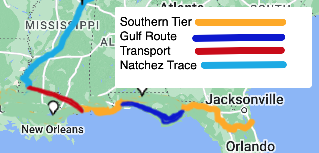
St. Augustine to Corvallis. There's a lot of country in between. I decided I could leave earlier in the spring if I started on the ACA Southern Tier, which starts in St. Augustine and heads west along the gulf coast. The other option would have been to head north along the Atlantic to the start of the ACA TransAm in Virginia. As this would have added a lot more miles I quickly decided against it.
So heading west on the Southern Tier, but I need to angle north, and I really don't want to ride through Texas. My friend Melissa had recently ridden the Natchez Trace Parkway and highly recommended it. So how to connect to it from the Southern Tier and where to go after it? Turns out ACA has a Great Rivers South route which includes the Natchez Trace Parkway and continues north from there.
So now I'm headed north mostly following the Mississippi into Missouri. Missouri means one thing to cyclists and that is the Katy Trail. I'm sure that by the time I get that far I will be so ready to get off of the roads and away from traffic. The Katy Trail crosses the entire state of Missouri from St. Louis to Kansas City but I'll be catching it a bit south and west of St. Louis as I have no desire to ride through big cities.
From the end of the Katy Trail I'll have a choice to either continue west into Kansas and ride the Flint Hills trail, or head north into Nebraska and ride the Cowboy Trail. Right now I'm leaning towards the Flint Hills trail which is probably more scenic and has a better surface than the Cowboy Trail, plus it ends just a days ride back to the ACA TransAm route. But if I feel like more adventure I can head north and do the Cowboy Trail. It's nice to have options.
Once I hit the TransAm route I can follow it all the way home, but I might run into other options once I get there. Its really too far ahead for me to think. When I planned my route for New Zealand I really only had two routes in mind: the Alps2Ocean and the Otaga Trail. I had no idea how'd I'd get to them or what lay between. I played it by ear and it worked out great. That's really my style. I hate to plan in too much detail because I want to feel free to change it up and do something completely different if that's where the trails take me. That said I went ahead and bought a bunch of the ACA maps so I know I'll have some default routes to fall back on.

Looking at this map now I could see letting Google plot me a more direct route from Denver to Boise and avoid a lot of Wyoming, Northern Idaho, and Montana. I did the western part of that route on 2010 Northwest Passage tour so I wouldn't mind skipping it.