Ashland to Missoula. Over the Cascades and north to the Adventure Cycling Trans America bike route. Through Eastern Oregon and up lots of Rivers in Idaho,
Having been laid off after 17 years at Southern Oregon University I was free to do a longer tour. I had been training hard, putting in more miles than ever before over the winter and spring, and I was ready. June brought some nasty weather and I had to wait an extra week for the cold rain to stop.
This would be a ride of discovery for me. I had a grand plan of meeting Paul up in Glacier park, but no definite route. The rough plan was to head over the Cascades, head north, and join the ACA Trans Am trail east. The route would in parts follow the Lewis and Clark route, as well as the route Chief Joseph and the Nez Perce took from Oregon to Montana. Adventure awaits me.
Postscript:
I got as far as Missoula and then had to take a bus home. I rode for 21 days to get there, and 21 hours on the bus to get home. It was an amazing tour.
Lao Tzu said "The journey of a thousand miles begins with a single step", or in my case a pedal stroke. I probably average about 70 pedal strokes per minute. I pedaled for 5 and a half hours today which comes out to about 23,000 pedal strokes. Not a bad start.
Climbing up Greensprings It's definitely one stroke at a time. If you think much beyond the next pedal stroke you'll never make it. Likewise in programming you learn to break a big problem into small, manageable pieces.
The problems facing the world, our country, and many of us individually, can seem just as overwhelming as climbing Greensprings (with 50 pounds of gear). The only way to approach them is one small step at at time. We can make changes, both personal and global, if we just take them one pedal stroke at a time. I'm sure that's what Lao Tzu had in mind.
Other stuff:
I ran into a huge group of kids, mostly on mountain bikes, strung out from the Howard Prairie resort all the way to the big hill on highway 37. It was a group of 50+ 7th and 8th graders from Santa Barbara middle school, with some old gray beards herding them on. They drove up and started their supported tour in La Pine. They've been riding for 7 days, having done 57 miles yesterday. The rode to Diamond Lake and Crater Lake. They're camping tonight at Hyatt Lake before finishing their tour tomorrow in Ashland. What a great thing.
Today was probably as good as it gets for riding. It got pretty hot on the climb but there was always a cool breeze. It was quite cool an invigorating on top. It didn't get warm again until Dead Indian. Here at the campground it's nice and warm in the sun, but cool in the shade.
No service here at Jackson Kimball park so I'll post this when I pass through Chilliquin in the morning. Right now I'm trying to type and swatt mosquitos at the same time. This is a beautiful spot on the headwaters of the Wood River, but I'm pretty sure this is where all the mosquitos in the world are born.
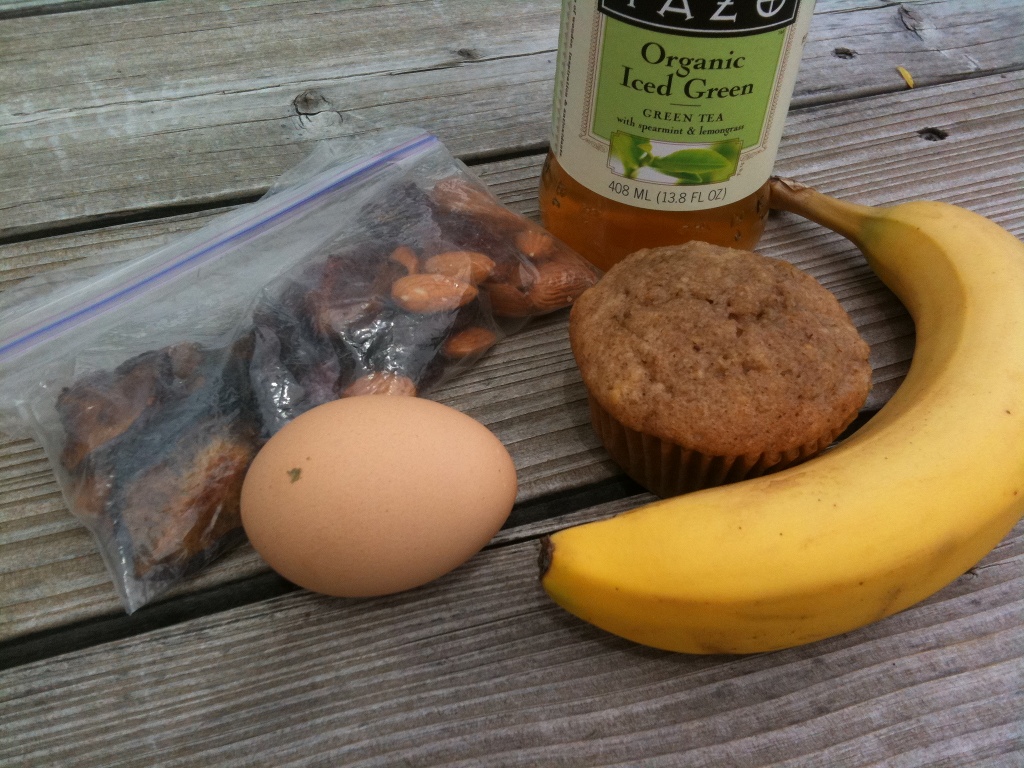
I had a much easier ride today. After a gentle 5 miles to the summit on highway 140, it was all down hill to West Side road. Then 20 miles of easy rollers followed by 7 miles completely flat, on in to Fort Klamath. There is a little store now at Joe's Motel that has organic food! I got a bannana, an oatmeal strawberry muffin, a hard boiled egg, and some ice tea.
The days are really long now. I got to the campground at 2:30 leaving lot's of time to do stuff. I took a water bottle shower. I wanted to use the river but it's very marshy and you can't easily get to it.
Looks like it will be a long day tomorrow. The gravel road I wanted to take looks very ridable. There is just the matter of these huge gravel trucks that are hauling through there at 60 miles an hour. I was also told the logging trucks would run me off the road. So I'll have to go south 10 miles to Chilliquin and get on highway 97 there. I was hoping to avoid 97 but that's where I'll be tomorrow.
I didn't really want to ride that many miles today. There were supposed to be several campgrounds back a way but I never saw them. Actually it was the easiest 86 miles I ever rode. Wind at my back most of the way. Cold wind I might add. It rained a little in the late afternoon and again at the campground, but this Central Oregon rain is pretty wimpy.
Ran into another bike tourist today. Derrick had ridden up from California. You can check out his journal. He had stopped to fix a flat when I ran into him. We road together for a while but then I turned off on hwy. 58 and he kept going towards Gilchrist.
Highway 58 was a fine ride, west back towards the Cascades. It was getting colder and even rained a little. The campground I wanted, on the Little Deschutes River, was not to be found so I kept riding. I realized I wouldn't have enough water if I couldn't find a campground, but I got some from a trucker who was stopped on the side of the road. It was late when I got to the campground but the days are long. I was the only one there. It was cold and lonely. Got the tent up, got a fire going, had dinner, and got to bed.
Decided it was too cold for the Cascade Lakes. Headed back to hwy. 97 on the Crscent cutoff road. Saw this about 2 miles from Crescent.
Had a nice deli sandwich at Gilcrest and saved half of it for later. It was still very cold so I decided just to head for Bend and stay at a motel. The wind was mostly out of the west, sometimes at my back, sometimes at my face, but mostly from the side. Highway 97 has a pretty good shoulder the whole way. The best parts have a rumble strip and then a 4 foot lane to the right. I felt quite safe when it was like that.
I stopped along the way, when the sun was coming out, and setup the hammock between some pine tress a couple of hundred yards from the road. Had a nice nap but then it started getting cold and it was time to ride on.
Got to Bend about 6:30 and checked in to the Super 8. Had a great shower and went down the street for pizza a beer. Now doing laundry.
Took it easy today. 4 days of hard riding took it's tool. After a good night's sleep my body knew it was time for a change of pace.
Went to the REI in Bend to get a few things. Very upscale, in a shopping center with all kinds of exclusive shops. Ran into a roadie there who gave me directions through, and out of, town.
Very different today. Headed east out of Bend. Pretty soon I was rolling through juniper trees on a good road with little traffic. It felt good to relax after 2 days of highway 97. I decided to just coast down the hills and never touched my big chain ring once.
Eventually I was back in juniper country and started climbing gradually. I stopped for lunch at a park they have for ATVs (they ca then OHVs) with trails through the sage brush and junipers. The had several of these over quite a few miles. I stopped because there were picnick tables. I saw a few ATVs starting out, but they were soon out of sight and hearing.
Then it was a steep decent into another world, or another state. I coasted down into a steep canyon that looked more like Arizona than Oregon. It led to the Prineville Reservoir, which, as many reservoirs, is not all that pretty except for being a big body of water.
I stopped at the first campground I came to after the dam. I think this is the Crooked River. If you've ever stopped to look at the Crooked River wher hwy. 97 crosses it you know what a steep canyon it runs through. I'm sitting in my hammock as I write. There's no service so I'll post it tomorrow from Prinville. Right now the sun is on me and it feels like 80 degrees. In a minute a cloud will block the sun and the wind will come up and it will feel like 50. It's been like that all day It's only 15 miles to Prineville and it looks like I've got quite a bit more downhill ahead of me. I'll have to layer up for the morning ride. The sun will disapear behind the canyon wall early tonight, but it looks like decent exposure for the morning sun.
Things got a lot slower once I got east of Bend. I remember in the book "Zen and the art of motorcycle maintenance" he said that when he hit US 97 going west that the energy changed and everything started moving faster. I took offense when I first read that thinking that we were pretty laid back on the west coast. But there is no denying that things go at a slower pace once you get far enough away from the major population centers. Either that or my legs are just getting tired.
It was a nice, mostly downhill, ride into Prineville, where it was warm and sunny. I stopped at a park to call Linda. Then I picked up a subway and went to another park to eat it. Eventually I headed out of town, east on US 26.
At thus point I am now on the Trans-Am bicycle route 76 which goes from Astoria, Oregon to Yorktown Virginia. I expect to run into other cyclists on this route.
It was not far from Prineville to Ochoco Lake, my next destination. When I got there I was disappointed to find it fu;ll of RVs and campers and lot's of people. However thid is where I was meeting Adinah (my daughter) and Chris, so I got the last spot and was happy for it. It is actually a very nice place, and a large lake. Plus they had showers!
I ran into another bike tourist who is also heading east. His name is John and he is from Virginia. He took the train to Seattle and started riding there. He rode down the coast and picked up the Trans-Am in Astoria. He rode over McKenzie Pass, the first cyclist to do so this year. We decided to ride together and see how it goes.
Adinah and Chirs didn't get in until late, after I had gone to bed.
Adinah served up a nice breakfast for us and we hung out and visited for a while. It was going to be another sunny warm day. We decided that John and I would ride up to Ochoco Divide and Chris and Adinah would meet us there, after doing some exploring on there own.
We knew it was 25 miles to the summit and 2000 foot elevation gain. It turned out to be a great climb with only one short 6% section. The country changed again, first going through some nice farmland before climbing along Ochoco Creek. It was green and well watered the whole way. Soon we climbed out of the junipers and into the pines. I knew there was a campground at the top having stayed there on the way to Idaho in 2005. to put things into perspective, on that trip this was our stop the first night out. By bike it took me a week.
Adinah and Chris met us at the top and we had a nice lunch. It's great to be eating some good food. They decided to go look for the "Painted Hills" while we finished our ride to Mitchell.
It was a fast downhill from Ochoco Divide into completely different country. Much more arid with sparse junipers. The exception was a very nice farmstead along Bridge Creek, with a garden and an orchard. It was the first I have seen people growing food for humans instead of cows on the trip so far. Soon the road leveled off and it got very hot. We had a few miles to go to get to Mitchell. All we know about Mitchell was that they allowed camping in the "Lions Club park". When we got here we could see it was a really old, run down down, and we weren't sure what to expect. But sure enough there was a nice park with some willow trees, along the creek, and some tents already setup. We pulled right in to a picnic table under a roof, with lots of grass to pitch our tents. There was water and a bathroom with a flush toilets! All for free. It seemed ironic that the smallest, poorest town, would have the best accommodations for cyclists. We went into the store and they even had us sign their guest book.
Soon Adinah and Chris showed up and we sat around, I played her guitar, we had some snacks and beer. Then Adinah made the best dinner I've had in a long time. Lentil burgers and salad. Wow!
Soon some other cyclists showed up, also heading east. They are Jim and Kathy and you can read about there trip here. Jim soon discovered that someone in the neighborhood had an opened wi-fi access point. Here we are, on the edge of nowhere, far from cell phone service, and we have wi-fi! Not only that but the little roofed in area has power outlets. Out come the laptops, iPhones, blackberries. Kathy even has an iPad. It seems bicycle tourists are all techies. We all had to get to work on our blogs!
Another relaxed morning at the park in Mitchell. Had breakfast with Adinah and Chris and said our goodbyes as they have to head back to Portland.
Rode with John up the 6 miles of 4 to 6 percent grade to the top of Keyes Creek Summit. Then we pretty much coasted for the next 20 miles. I stopped to take this picture and ran into a trio headed west with a support vehicle, taking turns driving. One of them was completing the Trans-Am trip he started last year. The driver gave us gatoraide. He also told us about this campground, Clyde Holiday State Park.
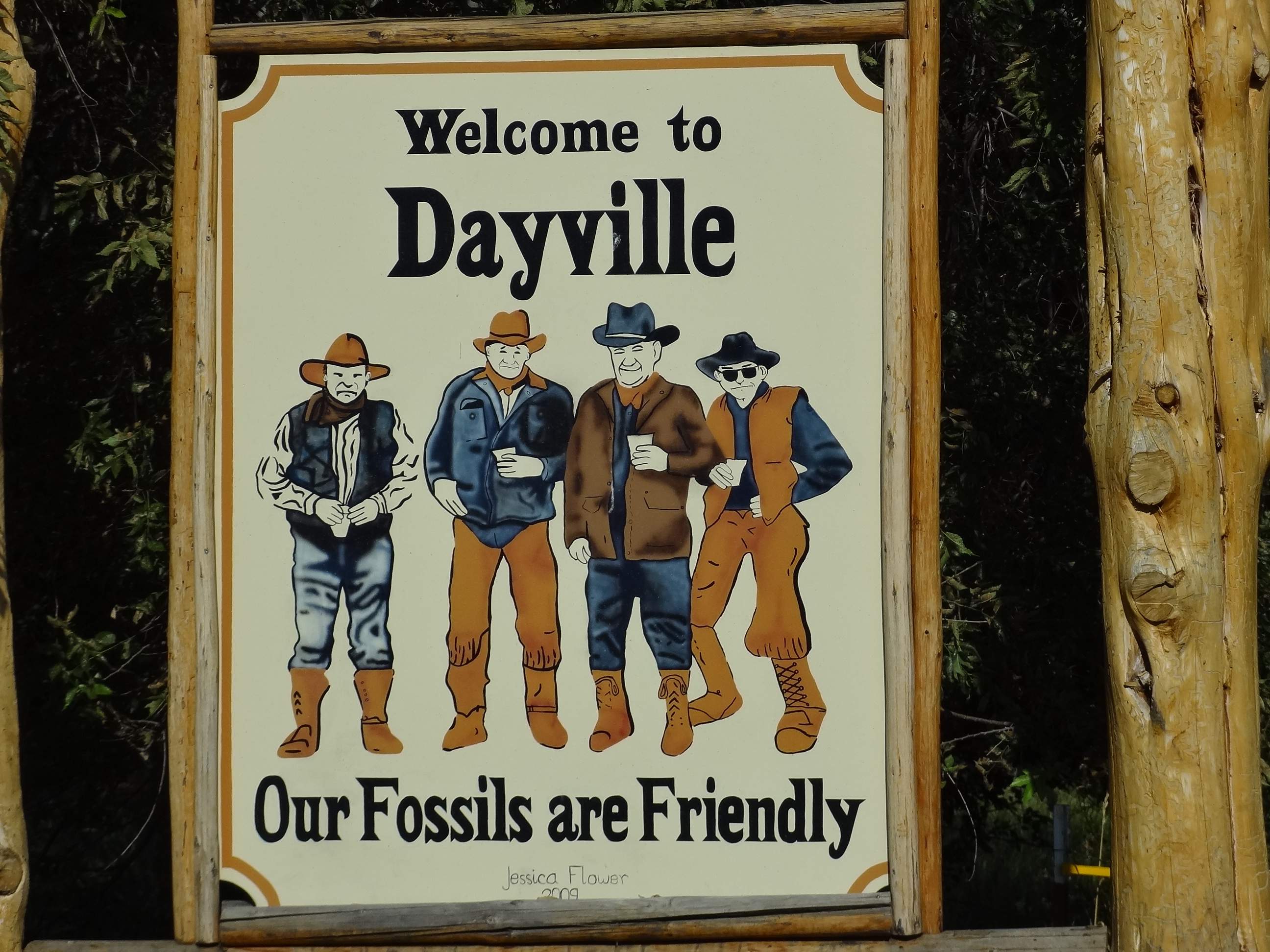
Dayville was unexpectedly green. The lady at the store said it was the rainiest spring anyone could remember.
Ran into Phil who was riding with his niece and a support car with Oregon license plate "velocar". They were riding unbranded carbon frames that they got cheap from Tiwan and then decked out with full Campy Record parts.
After that we had another 22 miles of easy riding to Mount Vernon. Stopped at the Silver Spur for dinner. Ran into 4 riders from Boise who where doing a week long loop. And then Phil showed up and sat with us. After dinner we proceeded to the Clyde Holiday state park which has hiker/biker sites. I was pleased to see Jim and Kathy, whom we meet the previous night in Mitchell, were already there.
The hiker/biker campground at Clyde Holiday State Park was great. I got a hot shower and slept warm and comfortable. The next town, John Day, was only a few miles. John Day is the biggest town in the area. We spent some time looking, in vain, for a fuel canister for John's Jetboil. All they have out here are the big Coleman canisters. I can see why so many people say that a white gas stove is the only way to go. I'm glad I picked up an extra canister in Bend, but I regret not insisting that John take it
As we approached Prairie City the Strawberry Mountains starting coming into view to the south. At 9,000 feet there is still snow on them.
The ride kept getting more and more scenic as we continued. We stopped for a long brunch in Prairie City. I had blueberry/rhubarb pie. John had some stuff waiting at the post office there. After Prairie City the mountains were even closer and quite picturesque across the green valley.
Soon we started to climb up the grade to Dixie Pass. No idea why something out here would be called Dixie. Once again the climb was a stead 4 to 6 percent. Each of the last three days we've had a climb similar to Greensprings but easier. On the way up there was a view point looking back on Strawberry Mountain.
Soon we were back in the pines and of course it was much cooler on top. Just half a mile from the summit was the Dixie campground which was John's destination for the day. Here we parted ways as I was heading on to Linda's high school friend Scotta's ranch further ahead. It was great riding with John these last few days. We looked at how we might meet up again but after today I'll be a day behind him, and if I go into the Wallows, a week behind.
I didn't take this shot, but this is the famous prairie schooner that we passed on the way up Dixie Pass.
So I continued along solo down the northeast side of Dixie Pass. Here the world changed again and it felt like I was back in Oregon. The pines on top gave way to a lush mixed forrest of pine, fir, and tamarack. I was reaally excited to see tamarack as I hadn't seen these since we lived in northeastern Washington. I expected the forrest to thin out as I descended but it didn't. I soon came to Austin Junction which was surrounded by forrest. The store/resturant was closed as expected. Here the Trans-Am route leaves US highway 26, which cuts southeast, and instead takes state highway 7, which heads northeast. Another mile up was county road 20 which was my cutoff for Boulder Creek Ranch. I would follow the middle fork of the John Day river downstream for 13.5 miles. This was a tough ride as there was a stiff wind comming up the valley. Fortunatley it was mostly downhill so I was able to keep it over 10 mph most of the way. The valley is well forested and quite scenic. It's mostly pines but you could see firs on the ridges.
Day 10 - Rest day at Boulder Creek Ranch
Les and Scotta have had this ranch for about 5 years. They here after living for many years near Salem, which is quite a change. This place is abount as remote as it gets, surrounded by BLM and tribal land. I didn't see any other places on the way in. They have horses and goats and dogs and a guest cabin which the rent out as a get-a-way destination. Very nice. Scotta served me a great dinner and showed me around the ranch. Today I'm taking a rest day as I've ridden for 9 days straight. It is much colder here, and today it is cloudy and windy. A good day to not ride.
The old shepherd's wagon where I slept my second night at Boulder Creek ranch.
It rained all night and was quite cold. In the morning you could see fresh snow on some of the ridges. I got up early enough to see Scotta before she left for work, and thank her for their hospitality. It was great to have a dry place to sleep and friendly people to visit. I hope I get back to Boulder Creek Ranch again someday.
It was cold and gray as I headed back up the middle fork of the John Day river, with occasional drizzle. I was able to warm up okay as the grade was slightly uphill. When I got back to hwy. 7 it started raining a little harder, but by the time I got my rain covers, and jacket on and got going again it stopped and didn't rain again all day.
I got warmed up just fine climbing Tripton pass. As has been the case for the last 4 climbs, it was a steady 4 - 6 percent, perfect for bike touring. At the top was a interpretive sign about the old railway that used to come trough here but eventually had to give up due to the amount of snow in the winter. The downhill was chilly but at least it wasn't raining. It was still well forested with ponderosa pine, and I had crossed over to the Wallowa-Whitman national forest.
The next climb came pretty quick and this one was different. Instead of one long steady grade there were shorter steeper climbs with easier sections in between. You could see Huckleberry Mountain to the south but I did not get a picture. Sumpter Pass was also over 5000 feet but had no sign. The downhill was fast and pretty soon I was cruising by the town of Sumpter. It was 3 miles off the road so I didn't stop. There was now a large and foreboding mountain range to the north with lots of fresh snow.
I stopped at Union Creek campground to see if any bike tourists were there and to have lunch. At $18 a spot they weren't going to get any bike tourists unless they were in a group. I had already made up my mind to continue to Baker City as it was too cold to camp.
After the reservoir the road started going downhill again following the Powder River. This of course was very confusing because the Powder River is in Montana and Wyoming. This Powder River feeds the Snake, while the better known one feeds the Yellowstone.
The road followed the river most of the way to Baker City. The river got wider and the valley opened up to ranches. Soon the pines gave way and the hillsides were mostly bare. Occasionally I caught sight of some very big, and very white mountains to the northeast. I'm pretty sure these were the Elkhorn range. The mountains I had been riding through, together with the Elkhorn and the Willowas are collectively known as the Blue Mountains of Oregon.
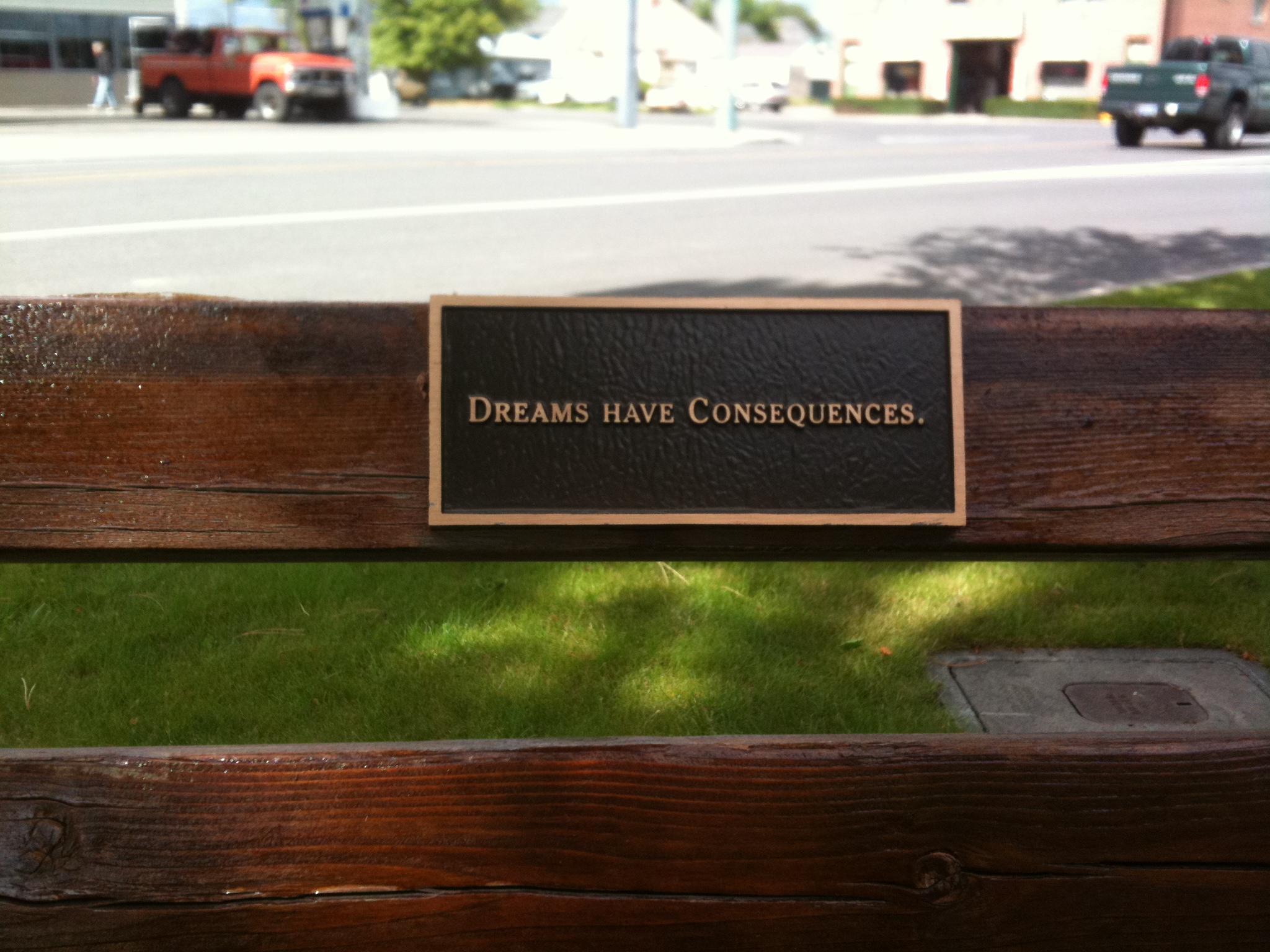
I got to Baker City at about 4:00 after a nice 66 mile ride. It was warmer and I was considering camping at one of the private campgrounds in town, but I found a nice enough motel and the lady even gave a discount to bike tourists because they are listed on the ACA Trans-Am map. I found a bench to sit down and call the motels when I saw this sign on a bench. Too much to think about.
Baker City is full of road racers here for the Elkhorn Classic Stage Race. The first stage is tomorrow. Do you think they'd let me ride along with the peleton?
Halfway, Oregon is one of the most beautiful places I have yet seen. It's like a hidden valley, very green, with the Wallowa mountains towering over it. The valley is wide with hay fields and horses, with lots of different trees along the creeks. The hillside to the west and north is pine forest, while the east slopes are mostly bare with trees growing up the draws. Much like Ashland in that respect. But the mountains are like nothing I've seen elsewhere.
I'm staying at a horse ranch, Lone Fir Friesians, that I found through warmshowers.org. Warm showers is a website where people can register to offer a place to stay to bike tourists. Inga, who owns this place, has been doing this for a while. She lives here with her 14 year old son and her boyfriend Dan. She's been here for 16 years raising and working these Friesian horses
They get 10 feet of snow here in the winter between December and March. Temperature between 10 and 20. Way too cold for me. I remember that I enjoyed living in northeastern Washington where it got much colder, -20, but now I can't handle anything much below 50. I wonder if it is a long term effect of a vegitarian diet?
I had a fun ride getting here. Met up with some young people, Kelsey, Rachel, and Dan, from Iowa. They rode the bus west and are riding east to Yellowstone. We parted ways in Richland where they camped, while I pushed on to Halfway. And a push it was with 3 miles of 7% grade over bare hills.
I woke up early to bright sunshine. It was a warm night, the warmest yet. Although this valley gets a huge amount of snow, the winters are relatively short, and it looks like they have a decent growing season. I'm setting on a little deck behind the barn looking out over lush hay fields at the southeastern most peaks of the Wallowa mountains. It's hard for me not to wonder what might have been had I been able to manifest a place like this and succeed at farming. This is ideal horse country here. Inga cuts and rakes hay with her Friesian horses. I did that with my Belgian draft horses years ago. There is nothing more timeless than working horses. Their slow pace just transcends time and space and you feel like you could be in another century, doing what farmers have done forever. I'm under no illusion that I could do that again. It's long hours of hard work. Then again so is bike touring. If I could ride 600 miles to get here who knows what else might be possible.
Well I made it to Idaho. I didn't really want to leave Lone Fir Friesians. I hung out all morning, even groomed some horses. They invited me to stay another day but I saw no purpose in it. I had that life long ago but didn't succeed. Time to move on. Here is another shot looking back over Pine Valley to the Wallowas.
I got very emotional as I rode out of Halfway. Don't know why. Guess it was bottled up. I stopped at the intersetion of the highway and talked to Linda for a long time. I wanted to turn right and head for home but I didn't. I turned left and road off to Idaho.
It was mostly downhill along Pine Creek to the Snake. Pine Creek would qualify as a river in most places. Not quite as big as the Rogue but well bigger than Bear Creek. And roaring. Lots of water.
I had originally thought about going off route and crossing the mountains to the Wallowa Valley. This road also goes by the Hell's Canyon Overlook. I kept debating if I should do this but when I got there the decision had already been made.
The Snake was somewhat disapointing. It's not really a river here but a series of reservoirs behind a bunch of dams. My first view was of a big hydro plant and power lines run by Idaho Power. Then I had about 12 miles along the lake/river heading south.
When I finally got to the crossing it was right below another huge dam. There was a nice campground just down from here but it was full. Big weekend. I had to climb another steep hill I hadn't planned on and fight to wind for 3 miles to get to this campground. I don't know why I bothered. There were people camped out at numerous places along the lake. Pretty much anywhere you could get a pickup. Not much shelter though. The campground is huge, and as expected, totally full of every type of RV you could imagine. The tent only camping was way in the back. I got one of two remaining tent sites. No privacy but a nice enough spot. This is by far the biggest campground I've ever seen. I'm sure there are well over a thousand people here.
Soon after setting up my tent I went to find a shower. Had to walk about a half mile. The shower was great but when I got out the wind was really blowing. I got back to find some stuff blown off the table and my rainfly flapping wildly. Some stakes had pulled out and nothing I could do would make then stay. After getting the rainfly under controll I threw the rest of my stuff in the tent and got in myself. It wasn't cold, just a fierce wind. It died down long enough for me to get out and make some dinner, but now it's blowing again.
It was windy and rained overnight but I was able to get going fairly early. I got warm pretty quick riding uphill. I knew I had a long hard climb getting up from the Snake River. It was a pleasant climb along Brownlee Creek. At first the hills were all bare with just some green along the creek. Soon it became quite lush along the creek with cottonwood and a bunch of smaller trees. At about 3,000 feet there were some firs and soon the ridges had fir and pine. I was pleased to have entered yet another national forest.
Once over the top the bare hills were back with just a few pines scattered here and there. I didn't expect to decend nearly as much as I climbed but it was downhill all the way to Cambridge.
Cambridge looked like a nice place that allows cyclists to camp in there water tower park. I also noticed a paved rail-to-trail that the map showed followed the Weiser river. At this point the route joined US 95, a much buiser road than Idaho 71 that I had been on. It was 22 more miles to Council, about half of which was slightly downhill. By now the land was mostly grazing and hay fields. At one point there was about a half mile climb to this mesa.
When I was about 4 miles from Council the shoulder, which had been pretty good, disapeared entirely. Then I noticed the rail trail was back running parallel to the highway so I decided to take it. It was dirt and gravel but not too bad so I took it all the way to Council. There were lots of these little sunflowers and other flowers.
It was getting quite windy and I could see rain off in the distance. By the time I got to Council it was really threatening though still holding off. I debated camping in the park, but it had no shelter at all. I finally opted for the motel. After a while I walked from the motel back into town to a store and the whole sky opened up. I can see why they've been talking about floods so much. It really rained. I was fortunate to get a ride back with the lady who runs the motel. I got back only half soaked, glad I wasn't camping. Of course the storm soon passed and it hasn't rained since.
Another gray cold morning leaving Council. My plan was to avoid the highway and take the Weiser River trail most of the way to New Meadows. I rode a few miles on it yesterday and it was fine. I had to ride north and then off-route to Fruitvale to get back on the trail, but I didn't get very far when I decided it was too hard. It was a little muddy and a little rocky and I decided it would wear me out, so I went back to the highway. Of course then I had a big hill to climb which wore me out just as much. I was thinking it was a beautiful January day in the Rogue Valley, but of course I was in Idaho and it was the first day of summer.
Some miles later, at the Evergreen Campground, I decided to try the trail again. I rode about 5 miles on it and enjoyed it pretty well. About a mile before it was supposed to end, the trail left it's natural course and took an abrupt turn uphill. I decided to turn back a quarter mile to a cross road I has just passed and got back on the highway. The Trucker was happy to feel pavement under it's tires again. Although it proved cabable off-road, I have to accept the fact that this bike is a true highway machine. We cruised the last few miles into New Meadows with ease.
The Weiser River Trail actually goes for 85 miles. I first saw it in Cambridge yesterday. It parallels the TransAm for about 50 miles and could easily be used as an alternative by bikes with mountain bike tires. Most of the time it would also be fine for 1.5 inch tires. The mud I encountered is certainly unusual for this time of year. I assumed this was a rail-to-trail but when riding it I had some doubts. For one the bed was not very wide or high. It could only have been one track. Also all of the bridges were created new for the trail. There were no signs of any old railroad bridges. I will Google it when I have access and post a link here. Done. It is indeed a rail-to-trail. The narrative says the part I was on has the roughest surface.
I stopped and had a hot chocolate at a place that had wi-fi and posted my last two blog entries, and then talked to Linda for a while. I wanted to do laundery but there was no laundermat in New Meadows. They said there was one in Riggins, 33 miles further on, so I decided to ride on. However I wanted to check out Zim's Hot Springs, 4 miles up the road, to see if I wanted to camp there. When I got going I was all set to cruise on to Riggins. The road was slightly downhill and I was rolling along at 18 mph. But when I got to the turnoff for Zim's the Trucker took the turn and here I am. Camp and soak for $12, with roofed over picnic tables (as it still might rain). They have a regular size swimming pool and a smaller hot pool. I have pitched my tent and a soak awaits me.
Wow, that was great. The hot pool is 105 degrees, and the swimming pool almost as warm. I couldn't last as long as I wanted. After days and days of riding your body just goes limp when exposed to any kind of relaxation. I had to get out while I still had the energy to stand. I thought I would get cold when I got out, but the sun started peeking though and although it's still mostly cloudy it has warmed up quite a bit.
So now I'm lying in my hammock warm and cozy thinking about what to make for dinner. Later on I'll walk back over to Zims and take advatage of his wi-fi to post this.
Today was all about the Salmon River, which I rode beside most of the day. The Salmon made up for my disappointment in the Snake. Unlike the Snake, the Salmon is wild and free.
But the day started on the Little Salmon River. This morning the road followed the Little Salmon down stream. While the road was slightly downhill, I knew it wouldn't get any steeper as I was following this slow moving river. All of a sudden the road narrowed, the shoulder disapeared, and started downhill at a much steeper grade. Where I camped last night it was a quiet meandering stream, but now it is a raging torrent.
I'm sure some of my river rafting friends know all about the Little Salmon River. The rapids continued on 20 miles to where the Little Salomon joined the Salmon at Riggins.
At one point, on the Little Salmon, there were trucks parked on both sides of the road and hundreds of people fishing. There were also some Nez Perse selling fresh Salmon out of a cooler.
Riggins is another river rafting capital, with numerous outfitters, tours, etc. all along the road. There were also jet boat trips to Hells Canyon.
I ran into Kelsey, Rachel, and Dan again just as they were about to go river rafting on the Salmon. Their biked were being shuttled to the take out point 10 miles down river in Lucile. I did laundery in Riggins before heading on.
From here on I was following the Salmon, which is a very big river.
Later on I met up with Kelsey, Rachel, and Dan and we rode into White Bird together. We cammped in their little park. The locals were mostly friendly. A woman came by and invited the girls to take a shower. I guess that happens to them a lot. Definite advantages for pretty young women not often afforded to us old geezers.
We were now following the Nez Perce trail and were now in White Bird Canyon, the location of the famous battle in which the Nez Pierce defeated the U.S. Army. My young riding companions were completely ignorant of the history of Chief Joseph and his band of Nez Perce. This seems like a significant part of American history, but I guess they don't teach it in school. Too bad. I took the opportunity to share what I knew.
The day began with a 10 mile climb out of White Bird canyon, past the site of the famous 1877 battle where the Nez Perce defeated the US army. The route followed the old highway so there was no traffic and lots of switchbacks of about 5% to 6%. You could see new highway which was a straight and relentless 7%. The view back the canyon was great. I was riding with the young trio of Rachel, Kelsey, and Dan, and wasn't really sure if I'd keep up. Fortunately Kelsey and Dan stopped now and then and when they did Rachel would slow down allowing me to catch up. When we got to the top the old road joined the new for a half mile.
We actually had another mile to climb after this on another old road with no cars. Soon we were cruising downhill but had to slow down to herd some cattle out of the way. I was afraid we would herd them all the way to Grangeville but we finally got them off the road.
We stopped for a Subway at Grangeville and then we parted ways. They were going to put on a lot of miles while I was going to meet back up with John.
After that I sat in the park and talked to Linda, then found the park where I'll be camping and setup my tent and write this. Now I'm going over to the pool to get a shower, find some wi-fi to post this, and maybe find the bike shop. Later I will meet John for dinner.
Another day, another river. Actually three rivers. But first, as we left Grangeville, we crossed Camas Prairie.
First came the south fork of the Clearwater. As we headed east from Grangeville it was all downhill. Pretty soon we were riding though the woods again when the river appeared. It was about the size of the Rogue, and in fact the surrounding trees and hills all looked very much like the Rogue Valley.
We've also been following the path that the Nez Perse took in their long flight from the Wallows to Montana. This will continue over Lolo Pass. We entered the Clearwater National Forest.
I keep saying we because I was riding with John again, and we also caught up with Jim and Kathy and rode most of the day with them as well.
At the town of Lowell the South Fork and the Middle Fork of the Clearwater join and we turned east and up the Middle Fork. We were now officially begining to climb the western slopes of the Rocky Mountains. The Middle Fork is much bigger than the South Fork, about as wide as the Willamette. It was mind boggling to think of all this water from the Clearwater, the Salmon, and the Snake, all feeding the Columbia.
We followed the Middle Fork through the Nez Perse reservation through the small towns of Stites, Kooskia, and Syringa. While I didn't see any signs of poverty, and the towns were not as run down as others I saw in Idaho, I didn't see any native people either. I'm not sure where they live.
At the town ( single store and gas station. The last one for 66 miles. ) we left the Clearwater and started riding up the Lochsa River.
By now the woods were very much like western Oregon, with pine, fir, and a lot of cedar. There were blackberries, thimbleberry, elderberry, and even a few alder. There also were other things I didn't recognize.
We ran into two seperate west bound riders. One was from Austrailia. They either had to have left really early, or be putting on big miles, to be this far west already.
We continue up the Lochsa river tomorrow, and the day after is Lolo Pass.
All along the wild and scenic Lochsa River. Awesome rapids the whole way and saw exactly one kyack in the water, though a bunch on cars.
I rode mostly by myself today though met up with the others from time to time. I was stopped at one point and a van pulled up and the woman driving asked me if I needed anything. I didn't but she gave me a granola bar, a banana, and filled my water bottle. Her name is Kim and she is sagging three guys who passed us a couple of days ago on the Little Salmon. They are doing the TransAm. Kim said they feel guilty seeing us self-supported riders, so she compensates by helping us out as well. A true trail angel.
With just a few miles to our destination, John and I were riding together with Jim and Kathy not far behind, when it started to rain. John and got to Lochsa Lodge, but Jim and Kathy never showed up. I'm assuming they stopped at one of the campgrounds back a few miles and decided to stay. We'll probably see them tomorrow.
We got our biked out of the rain and got a snack at the little store by the lodge. That's where we met Jodi who was also riding. She was riding a time trial bike and not packing anything. Her friend was coming with her stuff and they were camping at the Powell campground right next to the lodge. This was our destination as well. While we were still expecting Jim and Kathy to show up I went across to the lodge to use their wi-fi to send a message to Linda and post last nights blog. I then paid my $2.50 and took a nice hot shower. Soon Jodi's friend showed up and they headed down to the campground. We followed and took the spot next to them. Jodi's friend is Esther. Soon two other friends, Clint and Pay, showed up and proceeded to unload food and snacks on the picnic table at our site. I built a fire and the six of us talked for some time. Clint works for the forest service, and may works matching up Universities with projects that need to be done in the national forests. They appeared to all be in their 30's, well educated, and democrats. I believe Esther and Jodi live in Boise, Clint in Grangeville, and Pay in Missoula. I was really fascinated by these people. They made me feel like there may yet be hope for this country.
Tomorrow we climb the 15 miles to the summit of Lolo Pass, at which point we enter Montana. Then downhill to Lolo Hot Springs. I'll be in Missoula they day after tomorrow.
It was about 14 miles to Lolo Pass. For about half of this we were still following the Lochsa. We spent three days on this river.
After we left the river the climb got steeper but never more than 6%. There were a lot of clear cuts visible. The sign said there had been a massive fire, but it looked like clear cut to me. Before we new it we were on the top.
There is a big visitor center on the top. There was a trail run going on and two of the people we met were running in it, but it was over and they had left before we got there. The visitor center had wi-fi so we hung out there for a while.
We cruised down into Montana and to Lolo Hot springs. This is a private resort and I wasn't that interested but John was so we checked it out. We ran into a bunch of guys that were just finishing a 8 day supported tour. They did a different version of a tour through some part of the Rockies every year for many years. One guy had a lot to tell us about routes through the area. The hot pool was $6 so I went for it. Very nice. Glad I did.
After that it was time to say goodbye to John as he was going to camp at the hot springs, and then take a different route out of Lolo in the morning. It was good to have a riding partner for so much of this trip. I set out to be alone, and I like being alone, but I also like company, especially when riding through in familiar territory.
I continued on downhill to just before the town of Lolo. The route followed Lolo Creek, and there was this view of 9,096 foot Lolo Peak.
I'm staying at the Square and Round Dance Hall RV park. They have a tent section down by the creek far away from the RVs. Just me and a couple of motor bikers. I'm back in the land of cell phone service as well
Tomorrow will be an off day in Missoula as it is Sunday and things will be closed, including the Adventure Cycling Association which I want to vist to consult on my route.
Last night Paul R. called me and we decided Glacier was not in the cards for this year. Maybe next year and preferable with more people. Although I'm hooked on self supported touring and want to do a lot more, I can see that a supported trip like we did in Idaho in 2005, with 7 people, would be a lot of fun.
After talking to Paul I called Linda and she thought it best that I get home as soon as possible. Some things have come up that require my attention. So here I sit on a Greyhound bus heading west. The distance I traveled in 21 days will be erased in 20 hours.
Initially I thought I'd spend a night in Missoula and catch the bus tomorrow. The 11 miles from Lolo to Missoula was on a busy highway with a wide shoulder. Then I followed the bike lanes through the suburbs, downtown to the ACA headquarters. I knew they'd be closed on Sunday but just wanted to see where it is, thinking I'd be back in the morning.
From there I rode out to the Greyhound station hoping to find out about getting a bus. At this point it was still up in the air if I would. As I pulled up to the station I saw some bikes and before I could blink Kelsey and Rachel came running over, threw their arms around me and almost brought me and the bike to the ground. Dan was there too. Truely amazing that I would run into them again. I've read many people say that it's the people you meet while bike touring that is the part you'll always remember. It does seem that you can form close bonds in a short time while riding together and sharing an adventure. They had been two days ahead of me when Rachel's bike developed mechanical problems. They delay put them behind schedule so they decided to leap forward via bus and then ride the final leg to Yellowstone to meet their ride on July 1. Dan is on a different schedule and is spending another day in Missoula before busing to Steamboat Springs, CO.
They knew all about busing with your bike and told me where the bike shop was that had the box I would need. I checked the schedule and the westbound bus leaves at 8:00 am and 9:10 pm. I decided to go for it and catch the 9:10 bus. I got the box and stashed it at the bus station which would't reopen untill 8:30. I had the rest of the day to explore Missoula.
Missoula reminds me somewhat of Eugene. It's a college town, The Grizzlies, and has a river, The Clark Fork, running down the middle. There are numerous bike paths on both sides of the river and I tried to ride them all. It was hot, but not near Rogue Valley hot. I went to their "Good Food Store" which is a huge natural food supermarket and got some stuff for the bus ride. I asked a women on a bike for directions and she said she used to live in Ashland. It was obvious that Missoula is the liberal enclave of Montana.
After I rode all the bike paths I went over to the motel room Dan had and took a shower. Then the four of us went out for pizza. Then it was back to the bus station to start boxing my bike. This did not go well. The box I got wasn't near big enough. If it wasn't for help from my three friends, and a very acomodating Greyhound man, I never would have made it. He gave us extra cardbord boxed to cut up and tape over the protruding parts. As it is the "box" just barely fit in the cargo bay. I was a bit peeved when I saw a unboxed bike on board but was happy enough that I wasn't going to miss the bus.
By then Rachel and Kelsey were busy boxing their bikes for the 10:30 eastbound bus. I could see I would't be much help to them so I said goodbye, again. I will follow their adventures closely as I'm sure they have great things awaiting them.
And so my Northwest Passage tour comes to a close. Was it everything a bike tour should be? I think so. There were cold rainy nights, and warm sunny days. There were brutal climbs, and endless downhills. There was spectacular scenery, and boring scruby places. There were lonely back roads where you could let your mind wander, and busy shoulderless highways where you had to stay focused every second. There were days when I never saw another person, and days when I had great riding buddies. There were days when I felt tired and each mile was a struggle, and days when the miles flew by effortlessly. There were familiar places, and places that were totally unexpected. And always there were rivers and mountains and more rivers and mountains. My favorite experiences: camping in the park in Mitchell, visiting Linda's old friend at her ranch, views of the Strawberry mountains from Prairie City, and the Wallowas from Halfway, visiting the horse ranch in Halfway, the climb up White Bird Canyon, following the trail of the Nez Perse, and most of all the people I met and got to hang out with. I can't wait to do it again.