Lieb's Log

Day 17: 25 miles: Total 815 miles

The day began with a 10 mile climb out of White Bird canyon, past the site of the famous 1877 battle where the Nez Perce defeated the US army. The route followed the old highway so there was no traffic and lots of switchbacks of about 5% to 6%. You could see new highway which was a straight and relentless 7%. The view back the canyon was great.
Day 16: 66 miles. Total: 790 miles

Today was all about the Salmon River, which I rode beside most of the day. The Salmon made up for my disapointment in the Snake. Unlike the Smale, the Salmon is wild and free.

But the day started on the Little Salmon River. This is what it looked like where I camped last night

Day 15: 35 miles. Total: 724 miles

Day 14: 50 miles. Total: 689 miles

It was windy and rained overnight but I was able to get going fairly early. I got warm pretty quick riding uphill. I knew I had a long hard climb getting up from the Snake River. It was a pleasant climb along Brownlee Creek. At first the hills were all bare with just some green along the creek. Soon it became quite lush along the creek with cottonwood and a bunch of smaller trees. At about 3,000 feet there were some firs and soon the ridges had fir and pine. I was pleased to have entered yet another national forest.

Day 13: 39 miles. Total 639 miles

Well I made it to Idaho. I didn't really want to leave Lone Fir Friesians. I hung out all morning, even groomed some horses. They invited me to stay another day but I saw no purpose in it. I had that life long ago but didn't succeed. Time to move on. Here is another shot looking back over Pine Valley to the Wallowas.

Day 12: 62 miles. Total: 600

Halfway, Oregon is one of the most beautiful places I have yet seen. It's like a hidden valley, very green, with the Wallowa mountains towering over it. The valley is wide with hay fields and horses, with lots of different trees along the creeks. The hillside to the west and north is pine forest, while the east slopes are mostly bare with trees growing up the draws. Much like Ashland in that respect. But the mountains are like nothing I've seen elsewhere.

Day 11: 66 miles. Total: 538 miles

It rained all night and was quite cold. In the morning you could see fresh snow on some of the ridges. I got up early enough to see Scotta before she left for work, and thank her for their hospitality. It was great to have a dry place to sleep and friendly people to visit. I hope I get back to Boulder Creek Ranch again someday.

Boulder Creek Ranch

Image removed.
The cabin and barn at Boulder Creek Ranch with Dixie Butte in the background.

Day 9: 54 miles. Total: 472

The hiker/biker campground at Clyde Holiday State Park was great. I got a hot shower and slept warm and comfortable. The next town, John Day, was only a few miles. John Day is the biggest town in the area. We spent some time looking, in vain, for a fuel canister for John's Jetboil. All they have out here are the big Coleman canisters. I can see why so many people say that a white gas stove is the only way to go. I'm glad I picked up an extra canister in Bend, but I regret not insisting that John take it.

Day 8: 63 miles. Total 418 miles

Another relaxed morning at the park in Mitchell. Had breakfast with Adinah and Chris and said our goodbyes as they have to head back to Portland.

Image removed.
The park at Mitchell. I was very impressed with the hospitality of this tiny town.

Day 7: 40 miles. Total 345 miles

Adinah served up a nice breakfast for us and we hung out and visited for a while. It was going to be another sunny warm day. We decided that John and I would ride up to Ochoco Divide and Chris and Adinah would meet us there, after doing some exploring on there own.

Image removed.

Day 6: 30 miles. Total 305

Image removed.

Day 5: 40 miles. Total: 235

Took it easy today. 4 days of hard riding took it's tool. After a good night's sleep my body knew it was time for a change of pace.

Went to the REI in Bend to get a few things. Very upscale, in a shopping center with all kinds of exclusive shops. Ran into a roadie there who gave me directions through, and out of, town.

Day 4: 57 miles. Total: 235

Decided it was too cold for the Cascade Lakes. Headed back to hwy. 97 on the Crscent cutoff road. Saw this about 2 miles from Crescent.

Image removed.

Now that's the kind of sign a bicycle tourist likes to see. This was at the start to a bike path that followed the highway into town. The highway was smoother though.

Day 3: 86 miles. Total: 178 miles

I didn't really want to ride that many miles today. There were supposed to be several campgrounds back a way but I never saw them. Actually it was the easiest 86 miles I ever rode. Wind at my back most of the way. Cold wind I might add. It rained a little in the late afternoon and again at the campground, but this Central Oregon rain is pretty wimpy.

Day 2: 45 miles. Total: 92 miles

No service here at Jackson Kimball park so I'll post this when I pass through Chilliquin in the morning. Right now I'm trying to type and swatt mosquitos at the same time. This is a beautiful spot on the headwaters of the Wood River, but I'm pretty sure this is where all the mosquitos in the world are born.

Day 1: 47 miles. Total: 47 miles

Lao Tzu said "The journey of a thousand miles begins with a single step", or in my case a pedal stroke. I probably average about 70 pedal strokes per minute. I pedaled for 5 and a half hours today which comes out to about 23,000 pedal strokes. Not a bad start.

Climbing up Greensprings It's definately one stroke at a time. If you think much beyond the next pedal stroke you'll never make it. Likewise in programming you learn to break a big problem into small, managable pieces.

Getting ready to leave on Monday. Got my bike packed, but I'll probably take everything out and re-pack again to make sure I've got it right. Also got myself ready for everyday camping without the luxury of regular showers.

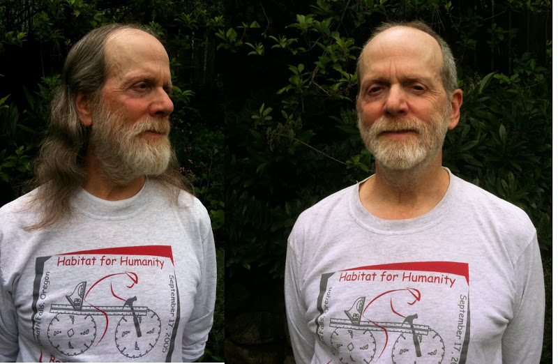
Before and after
The guy on the left doesn't get to go.

Took my touring bike for a climb today, lightly loaded. No problems. It was an overcast day and kept getting cooler the higher I rode.

Image removed.
Looking across to Mt. Ashland from Siskiyou Summit.