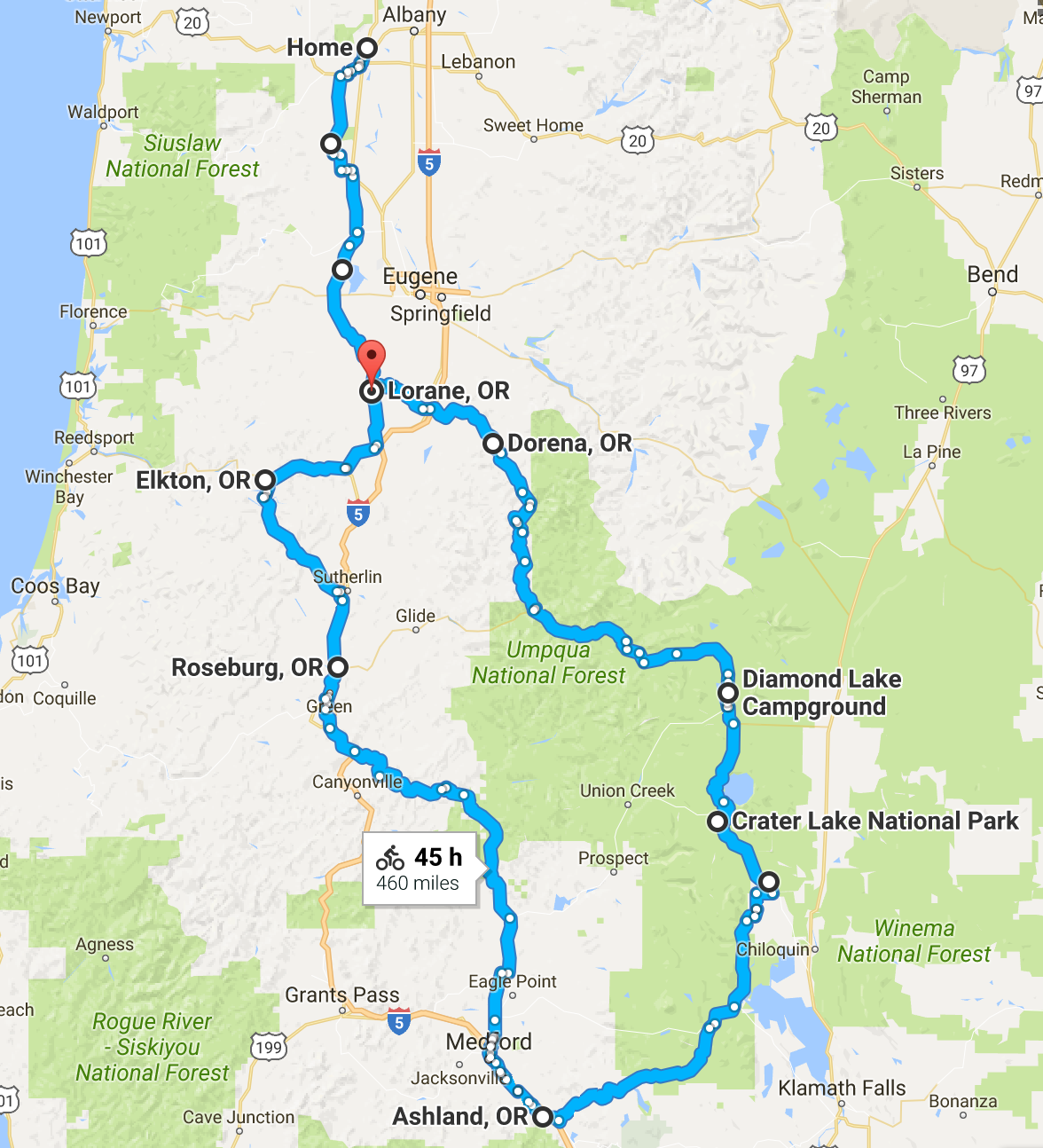
Met up with Charlie and Lorri at Diamond Lake, then Paul and John for the ride around Crater Lake on car-free day. Then a few days visiting friends in Ashland before the ride home.
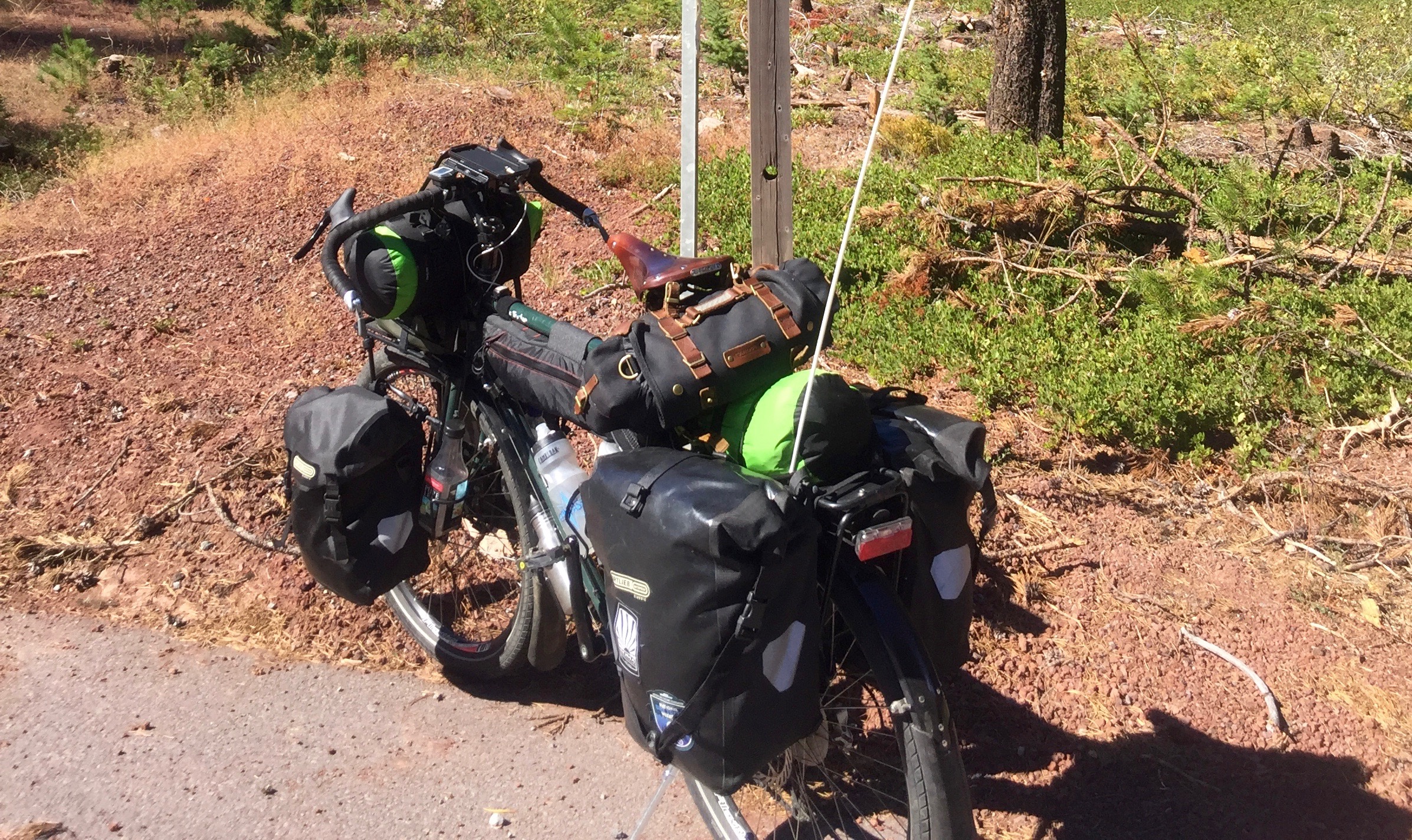
My exercise in overloading a touring bike. It was fine except for the steepest grades. I'm really not carrying any more stuff then usual, I just have it distributed better using the front harness, frame bag, and saddle bag. Not a bad setup really, but I really need to figure out how to lighten my load.
My first stop was the garden first to water and get some veggies for the trip. Green pepper, tomatoes, and kale will all survive several days in my panniers. I decided to take 99 instead of Bellfountain to avoid the hills, then from Monroe I took Territorial. Tailwind was great and I made it much farther than I had planned. It felt like a very good omen for a bike tour to have a tailwind get me started. Territorial had very little traffic. it was a lovely ride through farm fields and forests.
I had a snack at the Crow store and continued on down the road. I saw a really nice place to camp under some trees next to a field by a creek, but it was owned by some rick folks and the caretaker said he wasn't 'authorized' to let anyone camp there. I continued on and found an unlocked gate, with no 'no trespassing' signs, leading down to a neglected field with plenty of places to pitch my tent out of sight of the road. So that was my first camp. A quiet and very pleasant night.
Woke up and got going at a reasonable hour. Days are not long as they were in mid summer, but I knew I'd have plenty of daylight to get in the distance I needed. Had a little breakfast but no tea and hoped I'd find a cafe in Lorane for a good second breakfast. I was not disappointed. The Lorane store had a nice little cafe and I had tea and a second breakfast of eggs, hashbrowns, and toast. I think second breakfast might be the most important meal for bicycle tourists.
From Lorane I took the road to Cottage Grove. Here I encountered the first real climbing of the trip, though nothing like what I would encounter later on. There is a nice divide between the Coast Range valley that Territorial goes through, and the Willamette. It was a short climb though and soon I was cruising down into Cottage Grove. This is a town I have passed through on the freeway hundreds of times, and even stopped for the night at a motel, but never actually saw the town. Such is the beauty of bicycle travel. I stopped for a snack and a rest in a nice little park on the Row River, and then rode right down Main street. Cottage Grove really is a nice town that I never appreciated before.
I missed the turn to the Row River rail-to-trail, but that turned out to be a good thing. At some point I had the thought that I should get a map. Google is always a little sketchy when it comes to forest roads. Not long after I thought about it I saw a sign for the ranger station. It was still a few miles down the road but I found it, got a huge map of the Umpqua district, and chatted with the ranger. Things continued to work out well.
The road had a good shoulder with little traffic. Once again I missed a chance to get on the bike path. The paved rail-to-trail went on the north side of Dorena Lake and for some reason I thought I should stay on the south side. It wouldn't have matter. The road I wanted was well past the lake. I passed the lake and what I thought was the town of Dorena, where there was nothing, and then came to an old store that looked like it was on its last legs. They told me this was actually Dorena. I got water and a few other things to get me through the next day as I knew I'd be in the deep woods all day.
Some days are likea bike tourists dream. The last town I passed though before heading up into the woods was Culp Creek, once again with no services. As I entered the town I heard someone call out so I stopped. A guy about my age and his son were working on their house. They had never seen a loaded touring bike before. We chatted and they offered me a bottle of home brew to take with me. Can't beat that! I got to the campground 5 miles later and it was closed. I love closed campgrounds! Free camping and I had the whole place to myself. I found a sunny spot on the edge of the woods, put up my tent and drank the beer, then relaxed in my hammock, just thinking what a great life this is.
Another beautiful morning. Today I would cross over from the Row River valley, which is in the Willamette drainage, to the North Umpqua. The road was still as wide as a highway with a good shoulder and zero traffic. The first few miles were easy and I started fantasizing that it would be that way the whole way over the divide. Of course not! At about 8 mile up I came to a fork. The map showed the gravel road on the left, as well as the paved road on the right, both going through to Canton Creek road, which is the road down to the North Umpqua. There was a road sign saying to take the paved Clark Creek road, and so I did. It was a nice single lane paved road all the way over.
Very steep though. I had to push at least 2 miles of the 4 miles of 10% and steeper grade. Eventually I started noticing how high up I was and how stunning the views were. I was way up in the western Cascades. At the top there was a Y with no signs at all. The map showed the left fork as the road I wanted but it was very reassuring to see that someone had written "Steamboat" with an arrow on that road. Steamboat is the town on the North Umpqua I was headed for.
"Every mountain has a down hill, every mountain has a fast thrill, you may be crawling on the upside, but you'll be flying on the down side." Sung to the tune of "Good Old Rock and Roll" by Bob Seeger. Just a little ditty I made up to get me over the top. Sure enough I was soon flying down the mountain. In this case the downhill was much longer than the uphill had been. I had not seen one car, but just 3 motorcycles the whole way over. I ran into the first car 12 miles from the top. It was a guy pulling a teardrop camper. He said his wife was not far behind riding a bike. I said he'd better wait for her before it got steep as it was a really hard climb. I ran into her a few minutes later, riding a light weight road bike and looking really fit. I told her about the steep climb but had little doubt she would have no trouble with it.
I got out to the North Umpqua highway hoping to find a little store, but there was none. I didn't know at the time that the town of Steamboat was a little ways down the road in the opposite direction. So it was on to the campground, which was deserted except for Derral. Derral had living in the Apple Creek campground BLM campground all summer. He had a big pile of firewood and all the comforts of living in the woods. He invited me for dinner. A while later when I showed up he offered me a beer and said to fish it out of the cooler. He had a bunch of typical American beer and two small cans he said someone had given him. I took one of those and saw it was Caldera. "Caldera" I said, "this is brewed in Ashland, where I lived for 25 years". "Ashland" he said, "you must be a liberal. I hate liberals". It was an interesting evening. He still fed me dinner and we managed to tiptoe around the political discussions. It somehow escaped him that he was living all summer, paying $5 a day, in a federal campground, the kind that republicans would love to shut down. I enjoyed the food, thanked him for it, and then went off to play my shakuhachi along the North Umpqua river on a beautiful moonlit night.
Another beautiful morning. Nothing but sunshine so far. I'd driven the North Umpqua highway before so I sort of knew what to expect. There is a great mountain bike trail that follows the river, with trail access every 10 miles or so. I knew it was a real mountain bike trail and not something I could ride on my loaded Trucker. The road climbed steady but at a manageable grade. I was hoping to find a store to get some ice tea and soon noticed one of those 'road supported by' signs with 'Dry Creek Store'. Sure enough I soon saw the big sign on the highway saying 'Dry Creek Store - Opened'. Only it wasn't opened. It was closed permanently. Another rural business gone. There would be no store until Diamond Lake.
The North Umpqua is very scenic and has some amazing waterfalls. We had been to Lemolo Falls some years ago. Its a ways off the road and then a good hike in so I knew I wouldn't get there this trip, but I did stop at Clearwater Creek falls which is right on the highway. Another beautiful spot. There is a campground there as well. I talked to some people from California who were enjoying a road trip though Oregon.
There had been no cell service since I left Cottage Grove. I was to meet Lorri and Charlie at Diamond Lake but we had neglected to plan where to meet in the event of no wifi. I started to worry about this a bit as the day wore on. Then somewhere high in the mountains I came into cell service and things started beeping at me as messages came in. I continued climbing for what seemed like forever until I finally got to the Diamond Lake turnoff. There was a store right there and I stopped and got a drink, but passed on the ice cream thinking I'd get some at the resort further down the road. But then I rode right by the resort and soon came to the campground entrance. There are several campgrounds at Diamond Lake and we had discussed staying at either of the others, but not this one. I was exhausted and when I saw that the campground was mostly empty, and that there were great spots right on the lake, and that it would only coast me $8 with my senior pass, well not much to debate. I found a spot, got settled and pulled out my phone to let Charlie and Lorri know where I was. No service! What! I had service all the way in. So I rode back out thinking I'd have service up on the road. No luck. Starting to panic now I headed back to the resort a mile or so back down the road. For a minute I had service and tried to text them, but it didn't go through. I got to the resort, the lodge, and they had wifi. Lucked out again. Got my message through, and confirmed our camping spot. Got some ice cream and other treats at the store, and headed back to camp.
It was a beautiful spot and I got to watch the sun go down on the opposite side of the lake. Lorri and Charlie didn't show up until after sunset but they saw it fro further back. They brought dinner so we feasted and enjoyed the evening. The full moon soon rose and it was a spectacular night. I sat down by the lake side and played my shakuhachi before bed.
Today I had a riding buddy. Lorri rode with me while Charlie drove the car, took care of the dogs, and got our campsite. We wandered around the Diamond Lake campgrounds a bit trying to find a bike path but soon got back on track. It was a few miles on highway 140 heading east before we got to the park entrance. All up hill of course. There was a long line of cars at the entrance, which at first was not moving. When we finally got there I just flashed my old-folks-get-in-free card (a.k.a. senior pass) and the ranger just waved us on. Free is good! There was a lot of traffic, more than I expected. It was a plesant climb, gentle at first but increasingly steep as we neared the rim. We stopped at a nice viewpoint on what they call the Pumice Desert as nothing much wants to grow on the volcanic debris there.
We finally got to the rim and stopped to celebrate. I was just shy of 200 miles from home. I have no idea what the cumulative vertical was but Corvallis is at about 250' and we were now over 7,000'. That's a lot of climbing! The weather was still great and it was warm and sunny on the rim. I had my bike leaning on it's kickstand and Lorri was sitting a bit too close to it when a big gust of wind came along and knocked it over, bashing her arm in the process. Fortunately it did not impede her riding. Even though we had ridden less than 20 miles at this point I think Lorri was impressed to have climbed to such an incredible place.
It was now time to navigate the construction we had heard about. The first part was new pavement! The pilot car took all the cars ahead and we pretty much had the road to ourselves. It was all up hill on this stretch. We got to the end of the new pavement and stopped at a viewpoint. We then had a mile or so of unpaved surface. It was not so much gravel as hard packed dirt and rocks. Not at all a problem for our bikes, which both had wide tires. I wondered how it would be for the skinny tire riders the next day.
We were soon at the tourist area on the west side and stopped at the restaurant for a snack. Then it was the really fast 3 mile downhill, followed by 4 more miles of mostly fast down hill, and then the campground.
We were hanging out at the store/bathrooms/showers at the entrance to the Mazama campground when we met Jessica. She was riding a gravel bike with very minimalist bikepacking setup. She had a front roll, a small frame bag, and a Revelate seat bag. She had come 300 mile from Truckee taking forest roads around Mt. Shasta, solo. Certainly more impressive than my 200 mile ride, but I have no problem being outdone by a much younger woman. We made friends with Jessica and she joined us for diner at the lodge. This was an introduction to bike touring trip for Lorri so I was really glad for her to be exposed to a solo woman bikepacker.
Awesome. Thousands of riders. Supported rest stops with water, Cliff Bars and fruit. A bit windy and cool but still beautiful.
Paul and John met us at the parking lot as planned. It was a bit cold to start but we knew we'd be climbing right away. Many riders were doing the ride in the opposite direction, presumably as an out and back to avoid the construction. As expected no one seemed to have too trouble on the unpaved section, and everyone had a blast on the new pavement on a fast downhill. There were more cars parked at north entrance than we'd ever seen here before. They were lined up for about a quarter mile past the gate.
The wind was starting to gust as we came around the east side. It remained a factor the rest of the day. It was never directly in our face, except maybe for the climb up to Cloud Cap, but the side wind made for some tricky descents. It was also partly cloudy and cooler than it had been the day before.
I was riding my Trucker. I left all my gear back at camp but I still had a very heavy bike over all of these hills. I did fine, not really climbing much slower than I do on a lighter bike. The Trucker was especially nice and stable on the fast downhills, something I really appreciated after my experience 2 years ago on the Grand Randonneur when I had some front end wobble issues. Though the GR is much better now (after installing a roller bearing headset) I still don't have as much confidence on fast downhills as I did on the Trucker. It was great fun.
This was certainly a different rim ride this year. The car-free days attract thousands of riders from all over. And this year there were 3 rest stops with lots of Cliff Bars, fruit, and water. I especially enjoyed the new nut butter filled Cliff Bars. I ate a bunch of them and really felt an energy boost on the last big climb. I don't think I had been eating enough on previous days of this tour. I will try and east more from now on.
Once again Lorri rode with me while Charlie drove ahead with the dogs. We were treated to a great downhill on Hwy. 62 after leaving the park. It went on and on until it eventually reached the flat lands a few miles from Fort Klamath. This was familiar turf for me, but Lorri had never been here before and this part of the trip was an unexpected bonus for her. Once on the flats we realized we'd be dealing with headwinds the rest of the day. I had originally planned to do the loop out to the Wood River, but once we got out on the flat I really didn't feel like climbing back up into the woods. It was a good choice because I had under estimated the distance to Rocky Point, and with the wind in our face it was a hard enough ride without adding more.
I was happy to see the little Organic Market was still alive at the old motel/cabins in Fort Klamath. We stopped to get some snacks and spent some time talking to a couple who were also coming from the Crater ride. They had done a lot of touring and the woman had a really nice touring bike from Sweat Pea in Portland. Lorri got to talk to her about her bikes and about the touring they have done, which fit right in with my mission to introduce Lorri to as much about touring as possible. After meeting Jessica, who was a hard core bike packer, this was a good contrast as these people's touring style was more like what we call "credit card touring" where you don't carry a whole lot and stay at motels, or B&Bs, rather than camping.
From Fort Klamath we headed out across the farmland towards Rocky Point. Even with the wind it was a pleasant ride. Once we got to Westside road we were up against the hills and at times were sheltered from the wind. It was a bit farther than I thought to Rocky Point but we still got there relatively early. We had a nice cabin waiting for us, and the store had beer, so what more could we ask for. I kicked back while Charlie and Lorri took out a kayak to paddle around in the reeds.
Got an early start. Very beautiful morning at Rocky Point. Its a great spot to see the sunrise over the lake and reeds. Took the side road along the lake front out to highway 140. 140 had a really wide shoulder, then no shoulder, then an adequate shoulder for the 2 mile climb. The climb was not steep` and soon I was at the junction for Dead Indian Memorial, the road to Ashland. It was still quite cool and shady in the woods but I was warmed up from the climb. I remembered why I like these woods so much. In the Coast Range and western Cascades the undergrowth is so thick you can't easily walk out into the woods. Here the woods are open and you can wander off anywhere, yet the trees are still good size with a mix of Doug Fir and Ponderosa Pine.
I took it easy stopping a few times to eat and drink and enjoy the morning. Before I knew it I was at Lilly Glen horse park so I stopped for lunch, hung in my hammock, and played my Shakuhachi, before the final climb to Buck Prairie.
The descent down into Ashland was spectacular. In all of my touring nothing matches this. The views of Mt. Ashland and the Siskiyous were breathtaking, as was the curvy mostly smooth road down. I was glad I had disc brakes and that I had tightened them a bit before the descent. As Ashland came into view nestled against the mountains at the end of Bear Creek valley, I remembered what a scenic spot it is.
I always get emotional on bike tours, partly due to the physical exhaustion of riding everyday, and partly from the exhilaration from the spectacular climbs and scenery. So riding down a fabulous mountain road to a place I called home for 25 years, and where my kids grew up, brought up a lot of feelings. I could move back here. Its a great place and I have good friends here. Its an option I will have to consider.
I rode through town directly to the Caldera pub and had a beer and second lunch. This is bike touring at its finest. Then proceeded to my hosts Dan and Ellen's house, which of course is on a street as steep as any of the mountain passes I rode over to get here.
I took my time getting out of town. I stopped at the Co-op for second breakfast, even though I hadn't done any riding since first breakfast, and ran into the Thursday moring retired guys breakfast. So I got to see Ed and Larry, which was really nice. So I had some oatmeal and talked with them for a while, and then got a few supplies and headed out.
It was threatening rain as I found my way down to the bike path, then it actually started raining as I met another bike tourist headed the other direction. He had been following the Sierra-Cascade ACA route but got of course and ended up in Medford. Unfortunate, but now he was almost to Ashland and back on route. I had a bit of a struggle getting through Medford myself, but finally found my way out to the roads that parallel Hwy. 62 out to Shady Cove. It had stopped raining by now and was a pretty nice day. Rogue River road on the other side of the river from 62, is a particularly nice ride.
Once I got on the Trail/Tiller road my plan was to just ride until I got tired and look for a nice place to camp. The road followed a completely dry river bed. I guess it was Trail Creek. It looked like it would be a good sized creek in the spring. I kept going until I had been climbing a good ways and then found a gated, but not signed, logging road off to the west. I pushed and rode my bike up this road for about a half mile until I found a nice spot and made camp.
There was still quite a bit of climbing to reach the top of the divide, which was also the start of Douglas County. What a stark contrast. On the Jackson County side it was mostly residences with no visible signs of logging. As soon as I hit Douglas County I was in a big clearcut, and immediately saw a loaded log truck pulling out of a side road. The next day I would ride though a few lumber towns and was glad to see the mills still operating, but today I just witnessed the cost of that prosperity. At least I was going downhill now, at a fast clip. The Trucker isn't quite as rock steady with a full load but I discovered it had more to do with the rear load than the front. I need to work harder at getting the rear load better balanced left and right.
I passed though a very small town called Drew before reaching Tiller and the South Umpqua River. There is a big ranger station before the bridge over the river, but that was about it. There were no longer any stores in Tiller. When I hit the South Umpqua I saw a USBR 51 sign. I later looked this up and could not find any reference of it on the USBR maps. Interesting. The road goes both ways along the river and evidently it's a good ride to continue upstream a ways. My route today took me downstream and into the impending rain. It was never more than a heavy mist, or light drizzle, but it was enough to require a rain jacket from time to time.
The South Umpqua is completely different, and not nearly as scenic as the North Umpqua. Rather than tick conifers this was mixed terrain with oaks, madrone, and a lot of scrubby stuff. It opened into a valley from time to time, but nothing that looked that rich agriculturally. Of course it was a gray, wet day. Everything looks better when the sun is shining. The road had a really good shoulder all the way to Days Creek, and then it completely disappeared in places, at the same time as the traffic increased. The rain was letting up by now and after a while the shoulder reappeared.
I got to Canyonville and had lunch at a Subway. This was another town that I passed so many times on the freeway but had never been in the actual town. From the freeway all you see is the big casino, but the town is nothing like that. Of course there was a big hill to climb on my way out of town. Although it seemed out of the way, the route north required that I continue west to Riddle, and so I did. From there I did go north again to Myrtle Creek. I got off route at Myrtle Creek and started riding out the wrong road. I didn't know how far it would be to Roseburg. I pulled in behind a fire station to check Google Maps, and though about camping there, but decided instead to find a motel. So I headed back into Myrtle Creek and got a room at the Rose Motel, which was cheap but adequate. Most of the other guests looked like they lived there, and I had a nice chat with a motorcycle guy who said he lived back up the Trail/Tiller highway but stayed here during the week while he worked at a mill. Across the street was a nice Mexican restaurant where I had beer and enchiladas and was a happy camper.
The I-5 corridor through this part of Oregon cuts through some narrow canyons and around a lot of hills. There is no easy side road that follows it directly. The first big challenge was Roberts Mountain Road. It wasn't really a mountain, just one of those big oak knolls, so how bad could it be? It turns to gravel? Great! I haven't had very much gravel on this ride. It got over 10%. Ugh! Here I was pushing my bike again. I don't like pushing my bike. I'm not sure how much lighter I'd have to get to make it up a road like this. I'm not sure I could do it empty!
Old 99 though Roseburg was a nice respite. There were still traces of another era when this was the main road and there were stores and motels all along the way. I had about 20 miles on this road, straight through town and on north. I had lunch at a Subway somewhere north of Roseburg. Then it was off on some more side roads. It started off very scenic, including a covered bridge. Then Metz Hill, which was a nice climb but not steep. Then back across the freeway and onto Goodrich Highway. This sounded fine although I was not happy that I was now riding due east away from the freeway, but when it started heading north again it started climbing, and then got steep, and pretty soon I was off the bike again and pushing. #!!@%###! Despair started to set in. I was way out in the hills and had no idea what lied ahead. But of course every mountain had a top, and eventually I was zooming down the other side, straight down to one of those big truck stops on the freeway at Rice Hill. So, time for ice cream and chocolate milk. Nothing like good treat to liven the spirits.
I feared there could be more big hills ahead but fortunately there were not. Shortly after the truck stop I got on Eagle Valley Road to Yoncalla, and left the I-5 corridor for good. Yoncalla is another town I have often seen the exit for but have never been through. This still being Douglas County it is a logging town. I stopped at the store and they seemed quite friendly. I was glad to see these towns surviving, even though I decry the destruction their livelihood causes in the woods. There must be a better way.
Eagle Valley road took me to Drain, and then it was on Hwy. 38 to Anlauf, where Territorial Highway begins. I was now on the home stretch. I just rode a couple of miles up Territorial before finding an open field with a for sale sign and a somewhat hidden spot to camp.
Broke camp fairly early. I knew it would be a long day. It was still cool but it was shaoing up to be very nice. Turned out to be the warmest day of the tour. This being Sunday the cafe in Lorane was closed, but the store was open, so I stopped for second breakfast. I stopped again in Crow for more ice tea, and then took a break at a park in Veneta. I took another break at the park in Monroe and had lunch. Then is was just keep on riding until I got home. That nice north wind that had got my tour off to such an easy start was now in my face, but it was not as strong. The valley and the view of the coast range was beautiful and it felt good to be getting home on such a nice day.
And then I was home, and another short, but challenging tour came to an end. Perfect weather, scenic roads, and good friends. All bike tours should be this good.